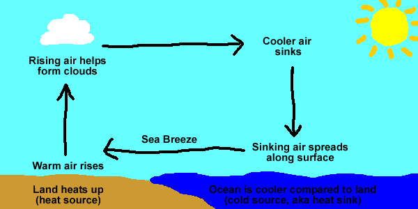
I stole this seabreeze diagram from the noaa weather website.

Sometimes, though, the general wisdom just doesn't hold up.
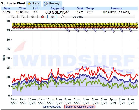
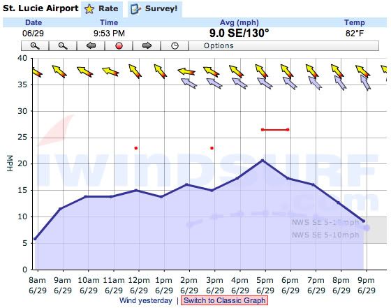
For example, this week the coastal waters along East Central Florida have been unusually cold, the land has been very hot, and the overall wind flow has been from the Southeast- a seemingly perfect set-up for seabreeze. Yet, the beaches have experienced nothing but light and unsteady breezes while, strangely enough, the protected lagoons inland from the beaches have been bathed in strong, steady wind. Thanks to the iWindsurf weather website I can prove that what I'm talking about is not just my imagination. Compare these two graphs of the wind from today:
1. This is from a wind sensor right near the beach at the St. Lucie Nuclear Power Plant. Notice how the average wind speed hardly gets over 10 mph, and the wind is very unsteady, full of gusts and lulls. The light blue dashed line is the forecast model's predicted wind strength, and you can see that the reality is a lot less than the prediction.

2. This is from a wind sensor about 4 miles inland from the beach at the St. Lucie County Airport. The wind was much stronger here, averaging 15-20 mph all day!

I asked the local windsurfers if any of them knew what might be the root of this counterintuitive phenomenon, and I got a variety of answers. Here's a summary of the main explanations that were put forth, with my thoughts in italics.
1. In East Central Florida the barrier islands are relatively narrow and the lagoon behind them is fairly wide, so the land-sea temperature interaction that causes the seabreeze is focused where the mainland meets the lagoon, not where the barrier islands meet the ocean. In other words, the barrier islands are less windy because they're too far offshore from where the main seabreeze is generated. I think this is a plausible idea that might explain some patterns in the strength of some seabreezes. But I don't think it explains what's going on this particular week in East Central Florida, because while poking around the barrier island where I live I've noticed that the breeze kicks in somewhere mid-island, and the lagoon is pretty windy all the way out to the inshore edge of the island. Also, the lagoon is much warmer than the ocean, so it's not like the span from the island through the lagoon is just an extension of the ocean.
2. There's a "funnel effect," aka a "venturi effect", wherein the geographic shape of the lagoon, which lines up roughly with South / Southeast seabreezes, accelerates the wind flowing through it. I think this might give a little boost to the seabreeze in certain parts of the lagoon, but I don't think it explains the whole thing. One potential problem with the funnel idea is that the land around the lagoon is very flat. This is Florida; there aren't any elevated landforms that could strongly channel the wind.
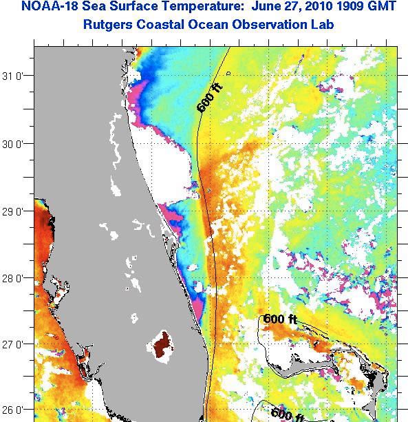
3. Cold water can have a layer of cold, dense air on top of it that prevents wind from mixing down to the level of the water surface. I think this is the main culprit behind the beach / lagoon wind difference occurring now in Florida. The cold water off the beaches comes from localized upwelling of deep water (see blue and purple in the picture below), so it's a lot colder along the beach than it is in the open ocean beyond the effects of the upwelling. Anyway, I think the seabreeze is composed of moderate temperature air from further out in the ocean, and it slides OVER the layer of really cool, non-moving air associated with the nearshore cold water upwelling. Then when it gets over the island and the warmer lagoon water it re-attaches to the surface.

The solution for windsurfers confronted with this situation is to temporarily give up on ocean sailing, and gear up with booties and shallow-water weed-shedding fins for blasting in the lagoon. Another solution that can sort-of work is to kiteboard on the ocean, because the kite gets up high enough to be in the good wind above the cold layer on the water. I had decent success with that a couple times this week, but also had long swims with a soggy kite a couple times when I dropped it into the dead wind zone where it was impossible to relaunch. Here's a video my buddy Russ took of one of the successful times.
Light wind kiting, Filmed from the beach from James Douglass on Vimeo.
James,
ReplyDeleteGreat write-up! I agree with your logic that it's the larger scale airmass that is moving and the upwelling is actually causing a "decoupling" along the coast.
A note about the graphs. The station at St. Lucie powerplant is part of our hurricane network and reports every 5 minutes hence the precision of the readings and more jagged look. The other station you have is a Public domain station that reports every hour hence the graph is so smooth. However the point of the graphs is spot on.. it was weaker at the coast and windier inland.
Drop me a line James as I'd love to pick your brain further. Mother nature always has the upper hand! ;)
Cheers,
Matt
matt@iwindsurf.com
Matt Corey
Chief Operational Meteorologist
WeatherFlow, Inc.
If you fill your kite with helium you'd have a perfect power with no need to relaunch! :)
ReplyDelete